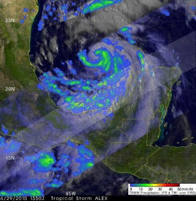
Hurricane Alex is generating some very heavy rainfall, and the Tropical Rainfall Measuring Mission satellite known as TRMM has been calculating it from its orbit in space.
As predicted by the National Hurricane Center (NHC) in Miami, Florida, Alex intensified after entering the warm waters of the southwest Gulf of Mexico.
At NASA's Goddard Space Flight Center in Greenbelt, Md., scientists created an analysis of Alex's rainfall using data captured by the TRMM satellite on June 29, 2010 at 1350 UTC (9:50 a.m. EDT). At that time the sustained winds around Alex were estimated to be 60 knots (~69 mph). Alex continued to strengthen and was classified as a hurricane early on 30 June 2010. This made Alex the first hurricane in the 2010 Atlantic hurricane season.
The rainfall analysis used TRMM Precipitation Radar (PR) data and TRMM Microwave Imager (TMI) data. The TMI data showed that a heavy band of precipitation (some areas showed rain falling at more than 2 inches per hour) was spiraling into the center of Alex's intensifying circulation. The precipitation analysis was overlaid on visible and infrared data from TRMM's Visible Infrared Scanner (VIRS). In the image created, Geostationary Operational Environmental Satellite (GOES East) visible image data was used to fill in locations not viewed by the TRMM satellite to form a complete picture of the storm.
Alex is expected to continue to be a large rainmaker when it makes landfall. Rainfall accumulations are expected of between 6 and 12 inches, with isolated amounts of 20 inches.
Tropical Storm-force winds are expected to reach coastal areas in the warning areas this afternoon, while hurricane-force winds will reach the coast tonight. In addition, the National Hurricane Center noted "a dangerous storm surge will raise water levels by as much as 3 to 5 feet above ground level along the immediate coast to the north of where the center makes landfall."
By 11 a.m. EDT, Alex was still a category one hurricane with maximum sustained winds near 80 mph. Alex was located about 145 miles (235 km) east of La Pesca, Mexico and 190 miles (310 km) southeast of Brownsville, Texas. That makes Alex's center near 23.8 North and 95.5 West. Alex is moving northwest at 7 mph (11 km/hr), and has a minimum central pressure near 961 millibars.
Satellite data show that Alex is a large hurricane and the hurricane force winds extend outward up to 60 miles (95 km) from the center. Tropical storm force winds extend outward up to 200 miles (325 km) primarily to the northeast of the center.
The National Hurricane Center noted today that "Given such a low minimum pressure...the current satellite presentation and a favorable environment for intensification...the winds should increase today and Alex could reach category two before landfall."

No comments:
Post a Comment